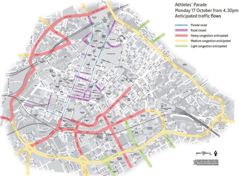
Transport for Greater Manchester (TfGM) has developed a heat map to help motorists who will be driving in and around the city during the Athletes’ Parade.
The map identifies the parade route, the road closures that will be in place for the event as well as areas where congestion is expected to be light, medium and heavy.
The map was designed following input from TfGM’s specialist urban traffic control team.The unit is responsible for management of the region’s traffic signals and monitoring congestion on its major roads.
Setting off from outside the Museum of Science and Industry, the parade will enter the Liverpool Road junction of Deansgate at 4.30pm before completing a route through the city centre, ending in Albert Square.
The family-friendly event has been timed to allow as many people as possible to enjoy the celebration and TfGM is working with operators and other partners to ensure additional parking spaces, trams and trains are available.
Event lead for TfGM, John Fryer, said: “The parade is creating a real buzz around the city and I for one cannot wait to welcome our Olympic and Paralympic champions.
“Since it was announced that Manchester would be front and centre of the celebratory events to mark our athletes’ remarkable achievements in Rio, we’ve been working tirelessly behind the scenes with our partners to plan and prepare for the event.
“We want to give spectators as well as commuters and other visitors all the information they need to make the travel choice that’s right for them.
“We are absolutely not discouraging car use; in fact driving into the region will be absolutely vital in getting some people into Manchester for the parade.
“The intention behind this heat map is to simply try to keep drivers cool under the collar. If they know where we expect traffic to be heaviest they can plan their journey appropriately.”


