
If one thing that can define a City, it is the rocks that it is built on and its Geographical location and Greater Manchester is no exception to that rule.
Geology has laid down the coal that drove the Industrial Age, the hills surrounding it provided the fast running water that initially powered the Industrial Revolution and the great mosses laid down at the end of the ice age and cut it off from much of the country until the 18th century provided the impetus for connecting it to other population centres by way of canals and railways.
Geology also provided the building blocks of Manchester-Take a look at St Ann’s Church in the City Centre.Its building blocks are that of fine to medium grained sedimentary sandstone rock dating from the early Permian age and laid down around 280 million years ago, as Manchester lay in the low altitude desert belts just north of the equator.
The sands of the desert were blown into dune formations and laid low until the Mancunians needed rocks to build their town.
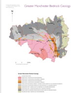
As a general rule the oldest rocks lie to the North East of the region while the youngest are in the South East
The upland moors of the Dark Peak and southern Pennines to the east of Manchester are formed in the Upper Carboniferous sandstones and shales of the Millstone Grit.
This is overlain by the shales, mudstones and thin coals of the Upper Carboniferous Coal Measures which underlie the undulating tract of land to the north of Manchester on which the towns of Oldham, Rochdale, Bolton and Wigan are located.
The outcrop of the Coal Measures also extends southwards down the eastern side Manchester through Ashton-Under-Lyme, Hyde and Hazel Grove.
Meanwhile much of the rest of the region is located on Permian sandstones and red Triassic sandstones and mudstones.
Of course in the timeline of the planet Manchester is young
The earth is around 4,600 million years old, its oldest surviving rocks are 4,000 million years old, the same time that the first organic life began to form.
The oldest known fossils date from 3,500 million years, oxygen first appeared in the atmosphere, 2,200 million years ago, the first animals 800 million years ago, 600 million years ago saw the first fish and verebrates, the earth’s surface began to turn green 500 million years ago and animals began to colonise the land 400 million years ago.
300 million years ago the first mammals and dinosaurs appeared and the landmass that would become Manchester was part of the supercontinent of Pangea and was located just to the north of the equator.
Here marine and fresh water shells accumulated and extensive growths of swamp vegetation would form the basis of the coal seams.
As the continent moved northwards under the influence of plate tectonics this would result in the sedimentary bedrock laid down and in this dry arid zone and desert winds would blow sound into dune formations forming the basis of the sandstone that forms the bedrock of much of the city centre and south and west.
During the last ice age which peaked around 21,000 years ago and ended around 11,500 years ago, the red sandstone would be covered by boulder clay or glacial till dumped by the moving glaciers.
These, what geologists call quaternary deposits gave rise to the poor drainage of the areas and the development of meres and peat mosses and as much as the deposits of coal would shape the industrial age would also contain the growth of the town for as a consequence, the lowlands, particularly around the Mersey Basin, contained large tracts of mossland which remained largely undrained until the middle part of the 18th century and it was not until the late 19th century that settlement in the south of the Manchester city suburbs began to grow.
Man probably first reached the British landmass between 850,000 and 940,000 years ago, Neanderthal Man was probably in Britain around 400,000 years ago as Homo Sapiens would hav arrived around 33,000 years ago.
Although there is no doubt they would have reached the North West, there has so far been no evidence discovered. The return of the ice sheets would have depopulated the area.
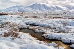
The final retreat of the ice between 13,000 and 10,000 years ago led to a rise in sea levels and an increase in rainfall .The tundra landscape of the retreating sheets was gradually replaced first by open grassland and then juniper willow and birch scrub before being covered by woodlands of Oak, Birch, Elm, Hazel and Lime.
The coastline in the NW was still very much different to what we see today with a belt of land from a line just west of Anglesey to Morecambe Bay more than 20km wide.
The earliest settlements in Lancashire can be dated to 11000-9500BC and are around the shores of Morecombe Bay
By 5000BC sea levels were close to where they are today and Britain was cut off from the continent
The Neolithic period would have seen lowlands of dry woodland whitest the upper slopes would have seen aurochs wild boar and deer roaming.
Oak Alder and Hazel covered much of the lowland and we saw the first evidence of human activity, families or groups clearing small areas of forest to grow cereal. They would stay for a few years before the topsoil was deleted and then would move on. 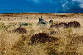
The original area would regenerate, alder birch,oak and Hazel would regrow but there would be more of an open canopy.By the end of the Neolithic period, much of the landscape was secondary forest.
This would be deer hunting territory. In Manchester itself, natural depressions in the clay would form inland wetlands creating fen lands. The Bronze age would see much of the forests cleared and the climate became cooler and wetter, bog and fen lands expanded and humans retreated to the middle and upper areas of the rivers.
As to when humans first settled in the region, the past few decades have seen changes in the view of the condition of northern England before the Roman occupation
What was once seen as an inhospitable landscape dominated by dense forests is now appreciated as one which, in the last millennium B.C., saw extensive clearance-episodes resulting in the development of local economies both agricultural and industrial which were, in late prehistory, more vibrant than was once thought.
David Shotter Professor Emeritus and an Honorary Research Fellow in the Centre for North-West Regional Studies at Lancaster University.
Indeed Thirty seven confirmed spots of Neolithic and Bronze Age occupation have been found around Greater Manchester indicating that there were economic activities which included hunting, woodworking and farming with activity suggesting the presence of permanent or semi-permanent settlement.
However no Iron Age settlement sites have ever been found within the District of Manchester, although Iron Age pottery from the Roman fort site in Castlefield, quern stones and metal finds of the Iron Age have been recorded
If there was any evidence of Phehistory in Manchester,it probaly got washed away during the cities rapid industrialisation
The Victorian Scholar Roeder speculated that Hunts Bank, the site of modern day Victoria Station, at the confluence of the Rivers Irk and Irwell could have been the site of an Iron Age fort and that this area was utilised by the Romans prior to building their defences at modern day Castlefield, but once again there is no evidence.
However Iron Age sites have been found around the region, most notably the hilltop enclosure at Mellor, defended promontory settlements overlooking the River Irwell at Rainsough, near Prestwich and The Burrs at Bury; and at Great Woolden Hall, on the River Glazebrook at the western edge of Chat Moss.
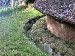
Oversley Farm, which now lies beneath the runway at Manchester airport, saw remains doscovered which date back to evidence of an early neolithic farming community which has been dated to 3975-3675BC


