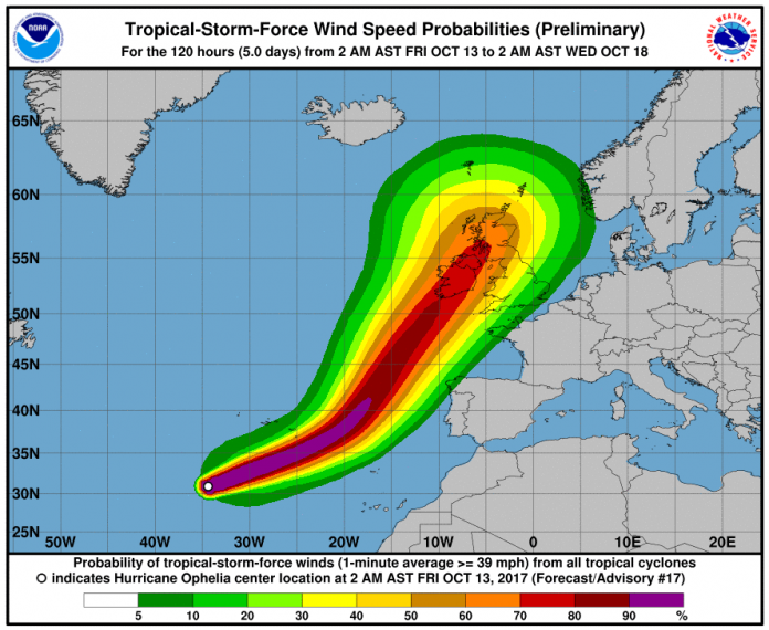
The Met Office have issued a yellow warning for wind from lunchtime tomorrow and into the late evening as the remnants of Hurricane Ophelia head our way.
The storm is on its way from the Azores in the Atlantic Ocean and currently blowing winds of 105mph.
According to the latest weather warning:
“12:00 on Monday until 23:55 on Monday
A spell of very windy weather is likely on Monday in association with ex-Ophelia. Road, rail, air and ferry services may be affected, with longer journeys times and cancellations possible. Power cuts may occur, with the potential to affect other services, such as mobile phone coverage. Some damage to buildings, such as tiles blown from roofs could happen, perhaps leading to injuries and danger to life from flying debris.
Coastal routes, sea fronts and coastal communities may be affected by spray and/or large waves. The warning has been updated to extend the area at risk further east, taking in much of northern England and Wales along with parts of southern and central Scotland. At the same time, much of northwest Scotland has been removed.”
It is expected to reach the West Coast of Ireland where the Republic’s Met Office has issued a red warning for counties in Munster and Connacht, predicting that coastal areas will be hit by winds in excess of 80mph by 9.00am tomorrow before heading NE towards the West coast of the Uk and Scotland.
Ophelia’s gusts are forecast to make it Britain’s strongest ex-tropical storm since September 2011’s Hurricane Katia.
The latest Met Office forecast issued for Greater Manchester states:
“After a breezy start, winds will strengthen, with gales across most parts, locally severe in the evening. It will stay mostly dry with some brighter spells likely and feeling warm. Maximum temperature 21 °C.”


